Difference between revisions of "Brugmann Mountains"
From Wikishire
(→References) |
|||
| Line 10: | Line 10: | ||
==References== | ==References== | ||
| − | * | + | *Location map: {{wmap|-64.033|-61.917}}) |
| − | *{{ | + | *{{basgaz}} |
{{Catself}} | {{Catself}} | ||
[[Category:Mountains and hills of the British Antarctic Territory]] | [[Category:Mountains and hills of the British Antarctic Territory]] | ||
Latest revision as of 16:42, 4 December 2022
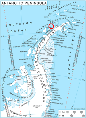
The Brugmann Mountains are a rugged range of mountains on Liege Island, in the Palmer Archipelago, part of the British Antarctic Territory. The mountains extend in a northeast–southwest arc along the east side of the island.
The Brugmann Mountains rise to 2,800 feet, are steep and rugged on the east slopes but are icecapped and descend gently toward the west,
Their principal peaks are Mount Vesalius, Pavlov Peak, Mishev Peak, Mount Kozyak, Vazharov Peak and Balkanov Peak.
The mountains were discovered by the Belgian Antarctic Expedition under Gerlache, 1897–99, and named by him for Georges Brugmann, a patron of the expedition.
References
- Location map: -64.033 -61.917)
- Gazetteer and Map of The British Antarctic Territory: Brugmann Mountains
