Difference between revisions of "Bibstone"
From Wikishire
(Created page with "{{Infobox town |name=Bibstone |county=Gloucestershire |picture=Near Poor End - geograph.org.uk - 32553.jpg |picture caption=Near Poor End, Bibstoen |os grid ref=ST699910 |lati...") |
|||
| Line 3: | Line 3: | ||
|county=Gloucestershire | |county=Gloucestershire | ||
|picture=Near Poor End - geograph.org.uk - 32553.jpg | |picture=Near Poor End - geograph.org.uk - 32553.jpg | ||
| − | |picture caption=Near Poor End, | + | |picture caption=Near Poor End, Bibstone |
|os grid ref=ST699910 | |os grid ref=ST699910 | ||
|latitude=51.617318 | |latitude=51.617318 | ||
| Line 14: | Line 14: | ||
|constituency= | |constituency= | ||
}} | }} | ||
| − | '''Bibstone''' is a hamlet in [[Gloucestershire]], on the B4058 south-west of [[ | + | '''Bibstone''' is a hamlet in [[Gloucestershire]], on the B4058 south-west of [[Charfield]]. |
==Outside links== | ==Outside links== | ||
{{Commons}} | {{Commons}} | ||
Latest revision as of 13:37, 20 January 2020
| Bibstone | |
| Gloucestershire | |
|---|---|
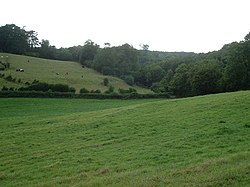
 Near Poor End, Bibstone | |
| Location | |
| Grid reference: | ST699910 |
| Location: | 51°37’2"N, 2°26’7"W |
| Data | |
| Local Government | |
| Council: | South Gloucestershire |
Bibstone is a hamlet in Gloucestershire, on the B4058 south-west of Charfield.
Outside links
| ("Wikimedia Commons" has material about Bibstone) |