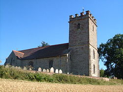
Bayton
From Wikishire
Revision as of 14:12, 23 March 2020 by Owain (Talk | contribs) (Created page with "{{Infobox town |county=Worcester |latitude=52.356208 |longitude=-2.449694 |population=443 |census year=2001 |picture=St Bartholomew's church, Bayton.jpg |LG district=Malvern H...")
| Bayton | |
| Worcestershire | |
|---|---|

| |
| Location | |
| Grid reference: | SO694732 |
| Location: | 52°21’22"N, 2°26’59"W |
| Data | |
| Population: | 443 (2001) |
| Post town: | Kidderminster |
| Postcode: | DY14 |
| Dialling code: | 01299 |
| Local Government | |
| Council: | Malvern Hills |
| Parliamentary constituency: |
West Worcestershire |
Bayton is a village and parish in the Doddingtree hundred of Worcestershire, adjacent to the border with Shropshire. According to the 2001 census it had a population of 443. The village is about 2½ miles south of Cleobury Mortimer. The Village Hall was built following years of hard work by local villagers. There is a church dedicated to St Bartholomew and within the Wyre Forest West group of parishes.[1]
References
| ("Wikimedia Commons" has material about Bayton) |