Difference between revisions of "Barrow Hill, Dorset"
From Wikishire
(Created page with "{{Infobox town |name=Barrow Hill |county=Dorset |picture=Thatched Cottage, Barrow Hill - geograph.org.uk - 1692127.jpg |picture caption=Thatched Cottage, Barrow Hill |os grid...") |
(No difference)
|
Latest revision as of 21:16, 14 May 2020
| Barrow Hill | |
| Dorset | |
|---|---|
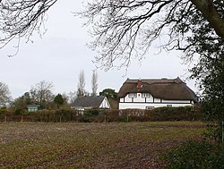
 Thatched Cottage, Barrow Hill | |
| Location | |
| Grid reference: | SY960958 |
| Location: | 50°45’44"N, 2°3’28"W |
| Data | |
| Postcode: | BH16 |
| Local Government | |
| Council: | Dorset |
Barrow Hill is a small settlement in Dorset, on the A350 road approximately 4.0 miles (6.4 km) northwest of Poole. It lies between Lytchett Matravers and Corfe Mullen.
This Dorset article is a stub: help to improve Wikishire by building it up.