Amble
| Amble | |
| Northumberland | |
|---|---|
 Amble | |
| Location | |
| Grid reference: | NU267041 |
| Location: | 55°19’50"N, 1°34’42"W |
| Data | |
| Population: | 6,044 |
| Post town: | Morpeth |
| Postcode: | NE65 |
| Dialling code: | 01665 |
| Local Government | |
| Council: | Northumberland |
| Parliamentary constituency: |
Berwick-upon-Tweed |
Amble is a little town and seaport on the North Sea coast of Northumberland. It stands at the mouth of the River Coquet, which forms the harbour, and the nearby Coquet Island is visible from Amble's beaches and harbour.
The town's nickname is "The Friendliest Port", which can be seen on the village signs and in use in the town.
The civil parish is called Amble by the Sea, and as of 2001 had a population of 6,044.
Contents
Name
The name of the town is not found in records until the thirteenth century, when sources suggest variants such as Ambell and Ambhill may have been in use as long ago as 1203.[1] Northumberland was not recorded in the Domesday Book.[2]
There are two suggested origins of the place-name Amble. The main theory is given by the Institute for Name-Studies at Nottingham University, which is Old English origin from Amma's/Anna's bile, meaning "Amma's or Anna's headland".[3] (In Old English, Anna is a known male name, though this far north it probably does not recall the famous King Anna of East Anglia.)
Another theory suggests a Gaelic origin, from Am Béal, meaning "tidal inlet", to be attributed to the historical presence of Irish missionaries in the area who spoke that language though the local folk did not.[4]
History
Various urns, cists, flint spearheads and other evidence of ancient burials were found near to Amble in the 1880s and 1890s. Some of those remains showed signs of cremation.[5][6]
Outcrops of coal had been found along the coastline between the River Coquet and the River Tyne at least as long ago as the reign of Elizabeth I, when unsuccessful attempts had been made to extract and transport it in an economic manner. A failed proposal to use Amble as a port for the shipment of locally sourced coal and salt is recorded in 1618,[7] although this failure did not discourage William Hewitt.[8]}} from making the then rare decision to reserve for himself the rights to the coal when he sold the townships of Amble and Hauxley in 1630.[9] A significant factor in the failure of all the early attempts, when compared to the success of ventures in the valleys of the Tyne and the Wear, was that of economies of scale. Those more successful areas at that time had plentiful easily accessed reserves which encouraged investment and the sharing of fixed costs such as harbour facilities, buildings and machinery among a large number of enterprises.[7]
The early situation changed as the operators in the valleys exhausted the cheaply-extracted ores and found themselves having to mine deeper and also further away from the rivers that were used for transport, thus increasing their costs per unit of coal mined. Some coal was probably being shipped from previously uneconomic places such Amble and Blyth by the end of the seventeenth century,[7] and it was certainly being extracted at Amble by that time.[10]
Amble grew in the nineteenth century as collieries were opened; and the newly-built railway links to the Northumberland coalfields made the town a centre for the sea transport and export of coal.[11] Prior to the development of the harbour, the town was "little more than a hamlet", according to the architectural guides originally compiled by Nikolaus Pevsner.[12] The principal local mineworkings were those at Broomhill and at Radcliffe.[13]
The harbour at Amble was the smallest of those that served the coalfields of Northumberland and Durham. It was originally under the control of the Dukes of Northumberland until, in 1837, a port authority - the Warkworth Harbour Commission - was created to supervise improvements. Following consultations with various engineers, the proposals submitted by John Rennie in 1838 were accepted. These included the construction of breakwaters to the north and the south, which were eventually completed in 1849 at a total cost of £116,000. The larger northern breakwater, which was originally 2,300 feet in length, was extended in the early part of the 20th century but suffered from the undermining effects of the tide and required shoring with slag brought in from the ironworks of Hartlepool and Middlesbrough.[14]
The construction of docks had also been mooted in 1844 and 1850 but the arrival of the railway led instead to the construction of coal staithes. A change in consulting engineer in 1869 resulted in extensive dredging of the harbour but did not greatly improve the prospects of the port. Shipments of coal amounted to over 500,000 tons by 1914 but this was a modest volume when compared to the other regional ports. Robert Rennison notes with regard to the relative lack of prosperity that the port served a "small and discrete coalfield".[14]
The 5.75-mile railway branched on a single track to Amble at a point near to [[Chevington, Northumberland|Chevington and was opened in September 1849 by the York, Newcastle and Berwick Railway, initially as a freight-only line. Passenger services between Amble and Chevington began in 1879, following the construction of a station at Broomhill in 1878 and facilities at Amble itself. The line between Amble and Broomhill was double-track. The passenger service ended in July 1930 and the general freight service was withdrawn in 1964. Coal traffic, which had amounted to around 750,000 tons annually in the 1920s, came to an end in 1969 when the line was closed completely.[15]
Other industries, such as sea fishing and both ship building and repair in an area known as the Braid had expanded with the growth of the town. Traditional Northumbrian fishing vessels such as cobles had previously sheltered in the natural harbour for centuries. One local coble manufacturing business, J. & J. Harrison, founded in 1870, had been the first to introduce engines to the form and was still producing it in 1973, along with more generally utilised craft.[16]
Present day

The Pevsner guide of 1992 says that "Today Amble is a not unpleasant small town but has few buildings of distinction." Of those, he records the church of St Cuthbert, which was originally constructed in 1870 and expanded in 1929, and its associated 1876-built vicarage. In addition, he notes some early Victorian terraces on Queen Street and North Street, as well as "a fragment of wall with a C 15 window, square-headed and of two trefoiled lights with uncusped sunk panels above. Though it may seem unlikely, this is an in situ fragment of the mediæval manor house. It belonged to Tynemouth Priory and may have served as a monastic cell." This latter is found on High Street.[12]
The fishing industry continues in Amble today, albeit with a reduced number of vessels, as does a small marine industry which is mainly concentrated around the construction and repair of yachts and other pleasure craft. A small industrial estate is located to the southwest of the town, whose clients include vehicle repairs and telecommunications companies. However, most of the units on the estate long remained unoccupied and the town has been affected by the closure of nearby businesses, such as a site operated by Alcan, as well as two food processing businesses in the town that employed nearly 300 people. A proposed retail development by Tesco had also been postponed due to poor trading conditions. The town's mayor announced that "the prospects for jobs are very bleak indeed."[17][18][19]
The Royal National Lifeboat Institute maintain a station at Amble.[20] There have been lifeboats operating from the town since 1842[21] and, for example, between 30 and 40 people perished in various wrecks near to Amble on 17–18 December 1872.[22]
Part of the harbour wall was damaged by flood in September 2008.[23]
Big Society
Amble Development Trust is a company operating as a charity with the purpose of working with other bodies to regenerate the town. It was established in 1994.[24] The Trust has been involved in numerous local projects to develop Amble both physically and socially, including having input on improvements to Queen Street, which is the main shopping thoroughfare.[25] The work of the Trust and its associated body, the Amble Strategic Partnership, was recognised by the Royal Town Planning Institute in 2003 when they were given the Institute's Planning for Town Regeneration award. This came soon after the same organisation had awarded them their Regional Award for Planning Achievement.[26]
Another project of the Trust is The Ambler, a bi-monthly community newspaper and website, established in 2000 and operated mainly by volunteers. The free bi-monthly newspaper is delivered to every house and business in the town.[27] The Development Trust and the town council have clashed from time to time.[28]
Tourism
Representations were made in 2006 for Amble to be included in the Northumberland Coast Area of Outstanding Natural Beauty, which ends at the pier. The town is also adjacent to nature reserves operated by Northumberland Wildlife Trust at Cresswell, Druridge and Hauxley.[29]
The town has a caravan park, as well as guest houses and bed and breakfast accommodation for visitors.[30] The Braid, which forms a part of the harbour, is now a greenfield site with a modern marina. In 2009, part of the Braid was legally designated as a Village Green, despite opposition from the council and the withdrawal of the initial application by the person who sought the status.[31]
The nearby Coquet Island is home to many varieties of nesting sea birds, including puffins and the rare Roseate tern. Access is restricted but there are various providers of boat trips around the island.[32] A £10,000 grant has been awarded to promote the town with a "Puffin Festival" during the last two weeks of May 2013, when the presence of that species on the island is at its peak. It is hoped that the grant will also encourage local people to use the town's shops.[33]
Friendliest port
In the 1930s, when the RMS Mauretania was heading on her last voyage to the breaker's yard at Rosyth, the town council of Amble sent a telegram to the ship saying "still the finest ship on the seas". The Mauretania replied with greetings "to the last and kindliest port in England".[34]
Pictures
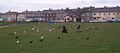
Birds on the grass in the car park leading on to the 'little shore'
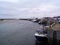
Small fishing boats moored-up.
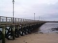
Amble pier
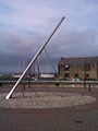
The sundial in the town square at the eastern end of Queen Street.
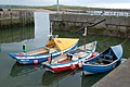
Cobles in the harbour
Town square, Amble


_-_geograph.org.uk_-_1366403.jpg)

Outside links
| ("Wikimedia Commons" has material about Amble) |
- Amble Town Council
- The Ambler Community Newspaper
- Northumberland Communities website
- fusilier.co.uk — Amble and District local history
- visitnorthumberland.com — Tourist guide
References
- ↑ Mawer, Allen (1920). The Place-names of Northumberland and Durham. Cambridge University Press. p. 5. http://archive.org/details/cu31924028042996.
- ↑ "Domesday Book". The National Archives. http://www.nationalarchives.gov.uk/records/research-guides/domesday.htm. Retrieved 24 January 2013.
- ↑ "Amble". Key To English Place Names. English Place Name Society. http://kepn.nottingham.ac.uk/map/place/Northumberland/Amble. Retrieved 24 January 2013.
- ↑ Younger, Paul L. (2010). "Ethnic Jostling in the North in the Sixth and Seventh Centuries AD". in Strachan, John; O'Malley-Younger, Alison. Ireland: Revolution and Evolution. Peter Lang. pp. 70–71. ISBN 978-3-03911-881-6.
- ↑ History of the Berwickshire Naturalists' Club. 14. Berwickshire Naturalists' Club. 1894.
- ↑ Amble and Hauxley (J. C. Hodgson, pages 121–124
- ↑ 7.0 7.1 7.2 Nef, John Ulric (2013). The Rise of the British Coal Industry. 2 (Reprinted ed.). Routledge. pp. 32–35. ISBN 978-0-7146-1346-8.
- ↑ "Dand v. Kingscote". The English Law Reports, Volume 4. 151. W. Green. 1915. p. 373.
- ↑ Nef, John Ulric (2013). The Rise of the British Coal Industry. 2 (Reprinted ed.). Routledge. p. 305. ISBN 978-0-7146-1346-8.
- ↑ Nef, John Ulric (2013). The Rise of the British Coal Industry. 2 (Reprinted ed.). Routledge. p. 41. ISBN 978-0-7146-1346-8.
- ↑ Amble - Amble Town Council
- ↑ 12.0 12.1 Nikolaus Pevsner: The Buildings of England: Northumberland, 1957; 1992 Penguin Books ISBN 978-0-300-09638-5 pages 145–146
- ↑ History of the Berwickshire Naturalists' Club. 14. Berwickshire Naturalists' Club. 1894. p. 255. http://archive.org/details/historyofberwick14berw.
- ↑ 14.0 14.1 Rennison, Robert William (1996). Civil Engineering Heritage: Northern England (2nd ed.). Thomas Telford. pp. 17–18. ISBN 978-0-7277-2518-9.
- ↑ "Northumbrian Railways: Amble Branch". Archived from the original on 4 April 2008. http://web.archive.org/web/20080404053548/http://www.northumbrian-railways.co.uk/amble.html.
- ↑ White, Brian (24 May 1973). "Shaky future for the coble". The Guardian: p. 19.
- ↑ "Annual Reports from Amble Groups/Organisations". Amble Town Council. 17 April 2012. http://www.amble.gov.uk/2012/04/annual-reports-from-amble-groupsorganisations/. Retrieved 24 January 2013.
- ↑ "Minutes of Amble Parish meeting held 23rd April 2012". Amble Town Council. 25 May 2012. http://www.amble.gov.uk/2012/05/minutes-of-amble-parish-meeting-held-23rd-april-2012/. Retrieved 24 January 2013.
- ↑ Daniel, Brian (10 July 2012). "Border Laird seafood factory at Amble set to close". The Journal. http://www.journallive.co.uk/north-east-news/todays-news/2012/07/10/border-laird-seafood-factory-at-amble-set-to-close-61634-31359650/#ixzz2Iig58ZeW. Retrieved 24 January 2013.
- ↑ "The RNLI at Amble". Royal National Lifeboat Institute. http://www.amblelifeboat.org.uk/. Retrieved 24 January 2013.
- ↑ "Our Station & Community". Royal National Lifeboat Institute. http://www.amblelifeboat.org.uk/station.php. Retrieved 24 January 2013.
- ↑ Wheeler, R. F.; Hoopell, R. E. (1877). "Meteorological Report, 1872". Natural History Transactions of Northumberland and Durham (Natural History Society of Northumberland, Durham, and Newcastle-upon-Tyne, Tyneside Naturalists' Field Club) 5: 55–56. http://archive.org/details/transactionsof5187376natu.
- ↑ Honeysett, Simon (17 September 2008). "Cracks in the harbour at Amble". The Journal. http://amble.journallive.co.uk/2008/09/cracks-in-the-harbour-at-amble.html. Retrieved 24 January 2013.
- ↑ "Amble Development Trust". http://www.ambledevelopmenttrust.org.uk/Version2/current/pages/about.htm. Retrieved 24 January 2013.
- ↑ "Projects". Amble Development Trust. http://www.ambledevelopmenttrust.org.uk/Version2/current/pages/projects.htm. Retrieved 24 January 2013.
- ↑ "Regeneration partners scoop national award". Northumberland Gazette. 7 February 2003. http://www.northumberlandgazette.co.uk/news/local-news/regeneration-partners-scoop-national-award-1-1479960. Retrieved 24 January 2013.
- ↑ "The Ambler". http://www.theambler.co.uk/about-us/. Retrieved 24 January 2013.
- ↑ "Amble public bodies at each others' throats". Northumberland Gazette. 14 October 2004. http://www.northumberlandgazette.co.uk/news/local-news/amble-public-bodies-at-each-others-throats-1-1488330. Retrieved 24 January 2013.
- ↑ "Natural beauty does not stop at Amble". Northumberland Gazette. 14 February 2006. http://www.northumberlandgazette.co.uk/news/local-news/natural-beauty-does-not-stop-at-amble-1-1368297. Retrieved 24 January 2013.
- ↑ "Your Northumberland Guide". http://www.yournorthumberland.co.uk/accommodation/amble.
- ↑ "Northumberland County Council". http://www3.northumberland.gov.uk/Councillor/Upload/CDocs/1049_M257.doc. Retrieved 24 January 2013.
- ↑ "Puffin Cruises". http://www.puffincruises.co.uk/.
- ↑ "Amble wins government cash to host puffin festival". BBC. 2 January 2013. http://www.bbc.co.uk/news/uk-england-tyne-20886789. Retrieved 24 January 2013.
- ↑ McCart, Neil (1990). Atlantic liners of the Cunard Line: from 1884 to the present day. Stephens. p. 85. ISBN 978-1-85260-065-5.
Further reading
- Morrison, Paul G.; Rylance, Tony; Anderson, John W. (1988). Amble: the friendliest port - a pictorial history of Amble, Northumberland. Gateshead: Howe Bros..
- Rippon, Bartle. The Amble Branch. Kestrel Railway Books. ISBN 978-1-905505-05-0.
- Hodgson, John Crawford (1899). Bateson, Edward; Hinds, Allen Banks; Craster, Herbert Henry Edmund et al.. eds. A History of Northumberland. 5. Newcastle-upon-Tyne: Andrew Reid & Co.. http://archive.org/details/historyofnorthum05nort.
- Fowler, Alexander (1935). "The Geology of the Country around Rothbury, Amble and Ashington". Memoirs of the Geological Survey, Great Britain: England and Wales (9-10).