A' Chailleach (Fannichs)
| A' Chailleach | |||
| Cromartyshire | |||
|---|---|---|---|
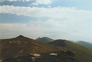
 A' Chailleach With Toman Cònnich and Sgùrr Breac beyond | |||
| Range: | Fannichs | ||
| Summit: | 3,271 feet NH135714 | ||
A' Chailleach is a mountain in Ross-shire, in the range known as the Fannichs, one of the nine "munros" in that range, which is to say mountains above 3,000 feet. A' Chailleach itself stands at 3,271 feet at its summit. It is in the Forest of Fannich, belonging to Cromartyshire.
The name of A' Chailleach is Gaelic, from the word Cailleach, a hag or femail ogre from the mythology of the Highlands.
A' Chailleach is the most westerly of the Fannaichs. The summit lies at the intersection of three ridges. The north ridge which terminates in the crags of Sron na Goibhre overlooking Loch a' Bhraoin, provides route up on its eastern slope to the north end of Loch Toll an Lochain. The southern ridge curves to An Sguman and is no route up to the sumit. The eastern ridge connects to Tomain Coinich which is connected to Sgurr Breac.
The mountain is well seperated from Sgurr nan Clach Geala and is not normally ascended as part of the same walk, but may be climbed conveniently with its neighbour, Sgùrr Breac. The usual approach is from the A832 to the north, and up the ridge which rises from the foot of Loch A' Bhraoin.