Tuosist
| Tuosist Irish: Tuath Ó Siosta | |
| County Kerry | |
|---|---|
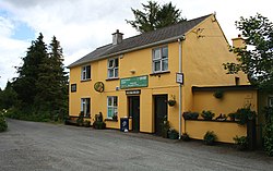
 Tuosist Post Office | |
| Location | |
| Grid reference: | V789628 |
| Location: | 51°48’16"N, 9°45’22"W |
| Data | |
| Local Government | |
| Website: | www.Tuosist.com |
Tuosist is a small village in the far south of County Kerry. It shares the Beara Peninsula with the neighbouring parishes of County Cork: the Caha Mountains here form the county border. The nearest town is Kenmare, nine miles to the north-east. The parish is part of the Barony of Glanrought.
The name of the village is from the Irish Tuath Ó Siosta, meaning 'Territory of O'Siosta.[1]
Local attractions include the Uragh Stone Circle, Uragh Wood, Cloonee and Inchiquin Loughs, the Healy Pass, Glenmore Lake, Derreen Garden, and Gleninchaquin Park.
Sport
- Gaelic football: Tuosist GAA
References
- ↑ Tuath Ó Siosta/Tuosist: Placenames Database of Ireland