World's End, Berkshire
| World's End | |
| Berkshire | |
|---|---|
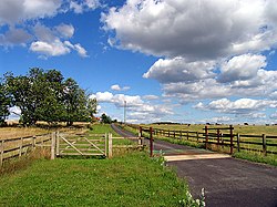
 Down Farm near World's End | |
| Location | |
| Grid reference: | SU487766 |
| Location: | 51°29’10"N, 1°18’0"W |
| Data | |
| Post town: | Newbury |
| Postcode: | RG20 |
| Dialling code: | 01635 |
| Local Government | |
| Council: | West Berkshire |
| Parliamentary constituency: |
Newbury |
World's End is a village in Berkshire standing near the A34 road north of Newbury. A small place, its name suggests remoteness but it is perhaps now more remote than once it was as the A34 bypasses it.
To the north is the village of Beedon (in whose parish it falls) and to the south lie Downend and Chieveley.