Reenard
| Reenard TOWNLAND Irish: An Rinn Aird | |
| County Kerry | |
|---|---|
 Reenard Point | |
| Location | |
| Location: | 51°55’59"N, 10°16’1"W |
| Grid reference: | V441780 |
| Data | |
Reenard is a townland in westernmost County Kerry. It is located in the north-central part of the Iveragh Peninsula, opposite Valentia Island and about five miles west of Cahersiveen. Reenard is connected to the Irish road network by a road crossing the N70 national secondary route at Point's Cross.
Reenard Point
- Location: 51°55’46"N, 10°16’37"W
Reenard Point in the townland is a headland facing Valentia Island to the west. It is the mainland terminal for the car ferry to Knightstown on the island.[1]
Railways

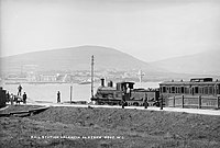
Valentia Harbour railway station was once the most westerly station in the British Isles. It was finally opened on 12 September 1893.[2]
The station closed on 1 February 1960.[3]
Sport
- Gaelic sport: Renard GAA
References
- ↑ Discover Ireland – Valentia Island
- ↑ "Valentia Harbour station". Railscot - Irish Railways. http://www.railscot.co.uk/Ireland/Irish_railways.pdf. Retrieved 2012-05-06.
- ↑ "Valentia Harbour Station". Railscot - Irish Railways. https://www.railscot.co.uk/Ireland/Irish_railways.pdf.
- An Rinn Aird / Reenard: Placenames Database of Ireland