Hutchesontown
| Hutchesontown | |
| Lanarkshire | |
|---|---|
_(cropped).jpg) Hutchesontown | |
| Location | |
| Grid reference: | NS594636 |
| Location: | 55°50’50"N, 4°14’38"W |
| Data | |
| Post town: | Glasgow |
| Postcode: | G5 |
| Dialling code: | 0141 |
| Local Government | |
| Council: | Glasgow |
| Parliamentary constituency: |
Glasgow Central |
Hutchesontown is an inner-city area in Glasgow, Lanarkshire. Mostly residential, it is situated directly south of the River Clyde and forms part of the wider historic Gorbals district.
The area is linked to Glasgow Green public park on the north side of the river by St Andrew's Suspension Bridge and King's Bridge. At its north-western edge, Albert Bridge is the closest crossing point towards Glasgow city centre. In McNeill Street, Hutchesontown has one of Glasgow's original Carnegie libraries, deftly designed by the Inverness-born architect James Robert Rhind. James Stokes, recipient of the Victoria Cross, was from the area.
Contents
History
Following the Second World War, Hutchesontown was declared a Comprehensive Development Area in 1957, in the aftermath of the Bruce Report.[1][2] This called for the mass gentrification of the area which took the form of |slum clearance and the replacement of overcrowded, insanitary tenement housing with new homes in high rise tower blocks.[3] The area became almost unrecognisable from its previous appearance, with blocks of tenements swept away along with several Victorian and Edwardian-era churches and civic buildings which in later times would have been considered to be of architectural merit.[4]
Hutchesontown was, in effect, used as a testing ground for similar schemes around the city. It was decided to divide the area into five "zones" which were given to different architects to implement a mixture of different schemes.
Pictures
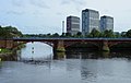
River Clyde and Waddell Court towers ('Hutchie B'), 2009

Ballater Street, 2009

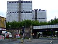
Waddell Street, 2013

Modern apartments on the site of Queen Elizabeth Square

19th-century St Francis Church, in 'Hutchie C' area but spared from the wrecking ball, now a community centre, 2012

Caledonia Road towers ('Hutchie D'), 2005, shortly before the demolition of two (right)

Gorbals Training Centre, McNeill Street (formerly Hutchesontown Library), 2013
Sandiefield Road towers ('Hutchie E'), 2011
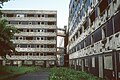
Low-rise Area "E" flats in 1987, shortly prior to demolition


.jpg)

.jpg)
.jpg)
.jpg)
.jpg)
.jpg)
Outside links
| ("Wikimedia Commons" has material about Hutchesontown) |
- Greater Gorbals, socio-economic profile at Understanding Glasgow (2012)
- Hutchesontown - Illustrated Guide
References
- ↑ Hutchesontown Housing (Glasgow City Archives, Department of Architectural and Civic Design, 1961), The Glasgow Story
- ↑ Lecture: Unbuilt Glasgow – The History & Impact of the Bruce Report, Fergus Sutherland & David Martin, Glasgow City Heritage Trust, 15 March 2017
- ↑ Hutchesontown: Housing, Everyday Life & Wellbeing over the long term, University of Glasgow
- ↑ Hutchesontown Gorbals - Architecture and History Template:Webarchive, Scotcities