Castlecove
| Castlecove Irish: An Siopa Dubh | |
| County Kerry | |
|---|---|
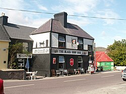
 A shop in Castlecove | |
| Location | |
| Grid reference: | V592605 |
| Location: | 51°46’46"N, 10°2’11"W |
| Data | |
| Local Government | |
Castlecove is a village in County Kerry, on the Iveragh Peninsula on the N70 road which forms part of the Ring of Kerry, on the south-western side of the peninsula.
While "Castlecove" is literally translated, in Irish, as Cuan an Chaisleáin, the officially recognised Irish name of the village is An Siopa Dubh.[1] An Siopa Dubh, which translates to "The Black Shop", is the name of a pub and shop in Castlecove. Historic Ordnance Survey maps, dating from 1897-1913, label the village as Blackshop.
References
- ↑ Siopa Dubh / Castlecove Castlecove: Placenames Database of Ireland