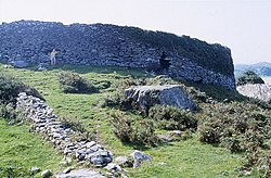
Caherdaniel
From Wikishire
Revision as of 12:42, 16 August 2024 by RB (Talk | contribs) (Created page with "{{Infobox town |name=Caherdaniel |irish=Cathair Dónall |county=Kerry |picture=Cathair Dónall (Caherdaniel) Ring Fort - geograph.org.uk - 1432501.jpg |picture caption=Cathair...")
| Caherdaniel Irish: Cathair Dónall | |
| County Kerry | |
|---|---|
 Cathair Dónall (Caherdaniel) Ring Fort | |
| Location | |
| Grid reference: | V548593 |
| Location: | 51°46’10"N, 10°5’59"W |
| Data | |
| Local Government | |
Caherdaniel is a village and townland in County Kerry, located on the Iveragh Peninsula and on the Ring of Kerry route. It is on the south-western side of the peninsula, facing onto Derrynane Bay, at a T-junction on the N70 road.
The name of the village is from the Irish Cathair Dónall, meaning 'Dónall's stone ringfort'.[1][2]
Staigue fort, a stone ringfort (cathair in Irish), is nearby.[3] Derrynane House, which was home to Daniel O'Connell, is also in the area. Copper ore was previously mined in Caherdaniel, the first mines dating back to about 2000 BC.[4]
References
- ↑ Mills, Anthony David: 'A Dictionary of British Place-Names' (Oxford University Press, 2003) ISBN 978-0-19-852758-9
- ↑ Cathair Dónall / Caherdaniel: Placenames Database of Ireland
- ↑ "Discover Caherdaniel". https://www.discoverireland.ie/caherdaniel.
- ↑ Noonan, Damien (2001). "Castles & Ancient Monuments of Ireland", Arum Press. ISBN 1-85410-752-6