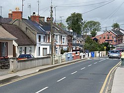
Riverchapel
| Riverchapel Irish: Séipéal na hAbhann | |
| County Wexford | |
|---|---|
 Main Street, Riverchapel | |
| Location | |
| Location: | 52°38’12"N, 6°14’2"W |
| Data | |
| Population: | First argument to "number_format" must be a number. (2016) |
| Local Government | |
Riverchapel is a village in County Wexford, just south of Courtown on the R742 regional road.
This has been a summer holiday resort for Dublin people at least since tourists started to arrive in 1863, when the railway line from Dublin reached nearby Gorey. The population of the area has also grown significantly since the mid-2000s. Riverchapel is half a mile inland from the Irish Sea coast and has merged into the adjoining village of Courtown.[1]
Both villages have many caravan parks and holiday homes. In the late 20th and early 21st century, significant urbanisation has taken place, especially in Riverchapel, with major expansions being done to local shops and the additions of new amenities such as a pharmacy and community sports complex. The population for the Riverchapel-Courtown area stands at 6,287 as of 2016, with these statistics including the surrounding housing areas of Ardamine and Poulshone.