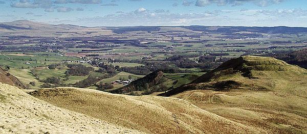
Tynron Doon
Tynron Doon is a multivallate Iron Age hill fort outside the village of Tynron in Dumfriesshire. It was occupied on and off from the 1st millennium BC until the 16th century, when an L-shaped tower house stood there. Tynron Doon lies at the southern end of the Scaur hills.
Description
The original site is thought to be a multivallate hill fort dating to the Iron Age, of much the same plan as the modern (20th C.) remains.[1]
The site is itself a spur hill of Auchengibbert Hill, and reaches 948 ft in height. The summit has an approximately oval plateau, of 130 by 150 ft in extent.[2] The fort was built in a natural defensive position defended by steep slopes on the north, south and east sides. The western approach was made defensive by the addition of three ditches and two ramparts, with some of the ditches rock-cut.[1]
In the 15th century the hill was the site of one of nine beacons maintained by the Sheriffs of Nithsdale and Annandale.[3]
In the late medieval era (c. 16th C.) an L-shaped tower house was built in the northwest corner of the central area, with floor plan of roughly 20 by 42 ft; a smaller 8 by 10 ft extension to the north-west is speculated to have been a tower stair.[1]
The tower house is thought to have been demolished between 1700 and 1750, used to build the church in Tynron (Tynron Kirk) and a barmkin wall fortification enclosing the summit may have been added in around the same period.[1]
A hut circle dating to the 18th/19th C. is thought to have been a shepherd's bothy.[1]

References
- ↑ Jump up to: 1.0 1.1 1.2 1.3 1.4 CANMORE 728679.
- ↑ CANMORE 1017429.
- ↑ Maxwell, Herbert Eustace (1900), A history of Dumfries and Galloway, p. 127, https://archive.org/stream/ahistorydumfrie00unkngoog#page/n146/mode/2up
Sources
- Williams, James (1971), "Tynron Doon, Dumfriesshire: A History of the Site with Notes on the Finds 1924-67", Transactions of the Dumfriesshire and Galloway Natural History and Antiquarian Society (TDGNHAS), 3 48: 106–120, http://www.dgnhas.org.uk/transonline/SerIII-Vol48.pdf
- "Tynron Doon", CANMORE - National Record of the Historic Environment (65300), https://canmore.org.uk/site/65300
- "Tynron Doon -Archeology Notes", CANMORE (728679), https://canmore.org.uk/event/728679
- "Tynron Doon - Publication Account", CANMORE (1017429), https://canmore.org.uk/event/1017429
Outside links
| ("Wikimedia Commons" has material about Tynron Doon) |
- Location map: 55°13’31"N, 3°51’25"W
- "Doon - Drumloff (track)", CANMORE - National Record of the Historic Environment, https://canmore.org.uk/site/65306
This Dumfriesshire article is a stub: help to improve Wikishire by building it up.