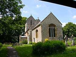
Ashton, Roade
| Ashton | |
| Northamptonshire | |
|---|---|
 St Michael and All Angels | |
| Location | |
| Grid reference: | SP767499 |
| Location: | 52°8’32"N, -0°52’50"W |
| Data | |
| Population: | 389 (2001) |
| Post town: | Northampton |
| Postcode: | NN7 |
| Dialling code: | 01604 |
| Local Government | |
| Council: | West Northamptonshire |
| Parliamentary constituency: |
Northampton South |
Ashton is a village in Northamptonshire about a mile south-east of Roade; close to the Northampton to Milton Keynes A508 road. It is to be found six miles south of Northampton and eleven miles north of Milton Keynes. The population of the civil parish at the 2011 census was 395.
The village's name means 'Ash tree village', or 'At the ash-trees'.[1]
Parish church
The church is dedicated to St Michael with the oldest parts 13th and 14th century. It was extensively restored in 1895. There are various monuments, including those to Sir Philip de Lou (d.14th century), Sir John de Herteshull (c.1365), and Robert Marriot (d.1584) and his family.
About the village
The village pub is The Old Crown Inn, on Stoke Road.
The village has a single Church of England primary school: Ashton C of E Primary School.
Outside links
| ("Wikimedia Commons" has material about Ashton, Roade) |
- Ashton, Roade in the Domesday Book
References
- ↑ Place-Names
