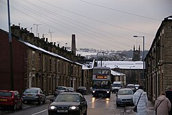
Copley, Cheshire
| Copley | |
| Cheshire | |
|---|---|
 Huddersfield Road, Copley | |
| Location | |
| Grid reference: | SJ974990 |
| Location: | 53°29’17"N, 2°2’24"W |
| Data | |
| Post town: | Stalybridge |
| Local Government | |
| Council: | Tameside |
Copley is a Cheshire village which has become in effect an area of the town of Stalybridge. It stands at the foot of the Pennines, eight miles east of Manchester.
The area has a local secondary school, Copley Academy, which is attached to a local recreational centre and swimming pool.