Ham, Berkeley

From Wikishire
Revision as of 18:40, 27 March 2023 by RB (talk | contribs) (Created page with "{{Infobox town |name=Ham |county=Gloucestershire |picture= Houses on the west side of Ham Green - geograph.org.uk - 4200597.jpg |picture caption=Houses along Ham Green |os gri...")
(diff) ← Older revision | Latest revision (diff) | Newer revision → (diff)
Jump to navigation Jump to search
The printable version is no longer supported and may have rendering errors. Please update your browser bookmarks and please use the default browser print function instead.
Ham
Gloucestershire

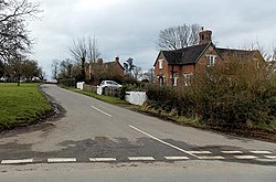
Houses along Ham Green
Location
Grid reference: ST679983
Location: 51°41’0"N, 2°27’53"W
Data
Postcode: GL13
Local Government

Ham is a small village in the Vale of Berkeley in the south of Gloucestershire. It is found just south of Berkeley and Berkeley Castle, separated by the meadows of a stream, the Berkeley Pill, on the low plain on the east side of the broad, tidal River Severn.