Kingston, Renfrewshire
| Kingston | |
| Renfrewshire | |
|---|---|

| |
| Location | |
| Grid reference: | NS438711 |
| Location: | 55°54’28"N, 4°29’57"W |
| Data | |
| Postcode: | PA7 |
| Local Government | |
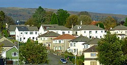
Kingston is a developed village in Renfrewshire, contiguous with Bishopston and considered part of the latter, tucked against the south edge of the M8 motorway and north of the railway line to Greenock.
This Renfrewshire article is a stub: help to improve Wikishire by building it up.