Trotton
| Trotton | |
| Sussex | |
|---|---|
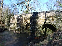
 Trotton Bridge | |
| Location | |
| Grid reference: | SU831225 |
| Location: | 50°59’48"N, -0°48’58"W |
| Data | |
| Postcode: | GU31 |
| Local Government | |
Trotton is little village beside the River Rother in Sussex, on the A272 road, which crosses the river near the parish church.
The bridge over the Rother here is a historic one, built of sandstone in about 1600 (and too narrow for two vehicles to pass). The bridge a Grade I listed structure.[1]
Parish church

The parish church is St George's, which dates to around 1230.[2] The church was rebuilt in about 1400.[3] The church is used by an Orthodox congregation once a month.
History
Trotton is listed in the Domesday Book of 1086 as Traitone and Trattone, in the Dumpford Hundred. It is recorded as having 14 households comprising four villagers and ten smallholders; with ploughing land, woodland, meadows, a mill and a church, it had a value to the lord of the manor of £5.[4]
In 1861, the population of the parish was 452, and its area was noted as 3,877 acres.[3]
Outside links
| ("Wikimedia Commons" has material about Trotton) |
References
- ↑ National Heritage List 1221337: Trotton Bridge (Grade I listing)
- ↑ Chatterton-Newman, Roger (1991). Betwixt Petersfield and Midhurst. Midhurst: Middleton Press. ISBN 0-906520-94-0.
- ↑ 3.0 3.1 Information on Trotton from GENUKI
- ↑ Trotton in the Domesday Book
