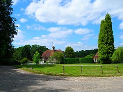
Titty Hill
| Titty Hill | |
| Sussex | |
|---|---|
 Titty Hill Farm | |
| Location | |
| Grid reference: | SU854257 |
| Location: | 51°1’30"N, -0°47’1"W |
| Data | |
| Postcode: | GU29 |
| Local Government | |
| Council: | Chichester |
Titty Hill is a tiny hamlet surrounded by woodland in the west of Sussex, in the Weald a mile south-east of Milland. It is close to the site of a Roman way station or mansio on the Chichester to Silchester Way.
The hamlet is not far from the borders of Hampshire to the west and Surrey. The Sussex Border Path runs through it.
Unsurprisingly, this hamlet has been frequently noted as an amusing place name.[1]
Outside links
| ("Wikimedia Commons" has material about Titty Hill) |
References
- ↑ Dave. "The 22 Worst Town Names In The World". Wordpress.com. http://thebestthings.wordpress.com/2007/06/01/the-22-worst-place-names-in-the-world/. Retrieved 30 October 2011.