Staplecross
| Staplecross | |
| Sussex | |
|---|---|
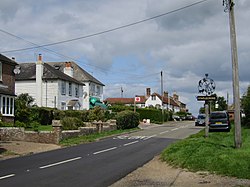
 B2165 road at Staplecross | |
| Location | |
| Grid reference: | TQ7812 |
| Location: | 50°58’25"N, 0°32’10"E |
| Data | |
| Population: | 760 (2011) |
| Post town: | Robertsbridge |
| Postcode: | TN32 |
| Dialling code: | 01580 |
| Local Government | |
| Council: | Rother |
| Parliamentary constituency: |
Bexhill and Battle |
Staplecross is a village in Sussex, in the parish of Ewhurst in the south-east of Sussex. It is perched is on a southern ridge of the valley of the River Rother which flows through Bodiam at the north of Staplecross.
The village is in the 'High Weald Area of Outstanding Natural Beauty'. The 2011 census recorded a population of 760.
Staplecross is found on the B2165 road which runs from nearby Cripps Corner to Beckley, four miles to the east. It is three miles east of the A21 road running north to south. The village is centred on the junction with Bodiam Road, which runs out to Bodiam Castle, two miles to the north.
Churches
- Church of England: St Mark
- Methodist: Staplecross Methodist Church
About the village
The village has a single shop, a village hall, with an adjacent social club, the Staplecross Club. There is one pub, The Cross Inn.
Sport
There is a bowls club, and a playing field with a children's play area.
Outside links
| ("Wikimedia Commons" has material about Staplecross) |
