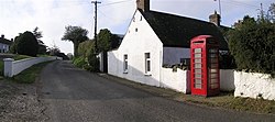
Donaghey
| Donaghey | |
| Tyrone | |
|---|---|
 Donaghey | |
| Location | |
| Grid reference: | H813714 |
| Location: | 54°35’5"N, 6°44’37"W |
| Data | |
| Dialling code: | 028 |
| Local Government | |
Donaghey is a small village and townland roughly halfway between Cookstown and Dungannon, just off the A29, in Tyrone.
The name of the village may be from the Gaelic Domhnach Eich meaning 'Church of the horse'[1] or Dún Eachaidh[2]
Donaghey has a range of facilities including a congregational church, a community hall, a primary school and a post office.
Church
- Donaghey Congregational Church
| ("Wikimedia Commons" has material about Donaghey) |
