Sutton Scotney
From Wikishire
Revision as of 14:14, 31 October 2022 by RB (Talk | contribs) (Created page with "{{Infobox town |name=Sutton Scotney |county=Hampshire |picture=The Old Fire Station, Sutton Scotney - geograph.org.uk - 65346.jpg |picture caption=The Old Fire Station |os gri...")
| Sutton Scotney | |
| Hampshire | |
|---|---|
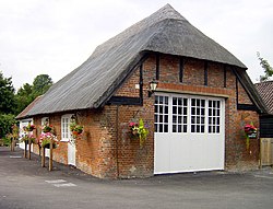
 The Old Fire Station | |
| Location | |
| Grid reference: | SU463395 |
| Location: | 51°9’10"N, 1°20’21"W |
| Data | |
| Population: | 1,346 (2011) |
| Post town: | Winchester |
| Postcode: | SO21 |
| Dialling code: | 01962 |
| Local Government | |
| Council: | Winchester |
| Parliamentary constituency: |
Winchester |
Sutton Scotney is a village in Hampshire, to the north of Winchester. It stands alongside the River Dever and is now bypassed by the A34 trunk road. It is notable for having been the site of numerous Spitfire crashes in the Second World War.
It has a population of more than 200, and had a watercress-based economy. Its best-known resident was J. Arthur Rank who took the name of the village as part of his title when he was ennobled.
The village pub, the Coach & Horses, dates back to 1762. It now incorporates the former thatched village fire station as bed and breakfast rooms.
Outside links
| ("Wikimedia Commons" has material about Sutton Scotney) |