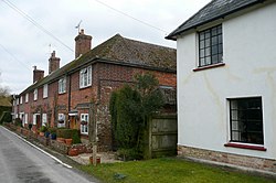
Popham, Hampshire
| Popham | |
| Hampshire | |
|---|---|

| |
| Location | |
| Grid reference: | SU539436 |
| Location: | 51°11’23"N, 1°12’3"W |
| Data | |
| Post town: | Winchester |
| Postcode: | SO21 |
| Dialling code: | 01256 |
| Local Government | |
| Council: | Basingstoke and Deane |
| Parliamentary constituency: |
Winchester |
Popham is a tiny hamlet in the north of Hampshire, to the south of Basingstoke, curbed behind the unforgiving path of the M3 motorway and the A33: the motorway's Junction 8 is just north of Popham.
The name of the hamlet is familiar to fliers and to drivers hurrying past on the A303 to the north, for Popham Airfield on the north side of the latter road. This and the Popham Little Chef restaurant are almost two miles to the west (in the neighbouring parish of Steventon).
The area was occupied from pre-historic times and was established as a permanent habitation during the Roman occupation of Britain. The manor of Popham was established by the monastery of Winchester as an outlying agricultural grain station. A small church and school were later established, but have long since disappeared. The parish and hamlet were later sliced in two by the M3 Motorway and A303 trunk road.
Manor
The manor of Popham was held from the 13th century by the family of "de Popham", later "Popham", which took its name from the manor.[1]
| ("Wikimedia Commons" has material about Popham, Hampshire) |
References
- ↑ A History of the County of Hampshire - Volume 3 pp 397-399: Parishes: Popham (Victoria County History)
