Pamber End
| Pamber End | |
| Hampshire | |
|---|---|
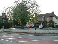
 The Queen's College Arms, Pamber End. | |
| Location | |
| Grid reference: | SU612585 |
| Location: | 51°19’20"N, 1°7’22"W |
| Data | |
| Postcode: | RG26 |
| Local Government | |
| Council: | Basingstoke and Deane |
| Parliamentary constituency: |
North West Hampshire |
| Website: | Pamber parish |
Pamber End is a small village in northern Hampshire, the southernmost of three Pamber villages in this part of the county spread up the A340. To the north is Pamber Green, and both are to the south of Tadley, a village leaning against the Berkshire border.
See also
| ("Wikimedia Commons" has material about Pamber End) |
References

This Hampshire article is a stub: help to improve Wikishire by building it up.
