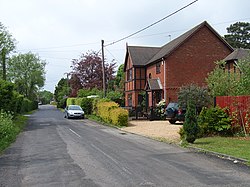
Mill Lane, Hampshire
| Mill Lane | |
| Hampshire | |
|---|---|

| |
| Location | |
| Grid reference: | SU795488 |
| Location: | 51°13’60"N, -0°51’46"W |
| Data | |
| Post town: | Odiham |
| Local Government | |
| Council: | Hart |
| Parliamentary constituency: |
North East Hampshire |
Mill Lane is a hamlet in Hampshire. Its nearest town is Fleet some two and a half miles away. The hamlet is on the A287 road between Odiham and Aldershot, in the east of the county. It is made up of a just few houses and a petrol station.
Bowenhurst Golf Centre is located nearby with a 9-hole pay and play course and a floodlit driving range.