Hill Brow
| Hill Brow | |
| Hampshire, Sussex | |
|---|---|
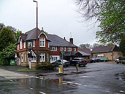
 The Jolly Drover. Hill Brow | |
| Location | |
| Grid reference: | SU788263 |
| Location: | 51°1’53"N, -0°52’37"W |
| Data | |
| Post town: | Liss |
| Postcode: | GU33 |
| Dialling code: | 01730 |
| Local Government | |
| Council: | East Hampshire |
Hill Brow is a small village sitting across the border of Hampshire to the north with Sussex to the south, the border marked here by the old course of the London to Portsmouth road running through the middle of the village; now the B2070.
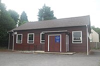
Most of the village is on the Hampshire side, and here are the village's two churches: St Agnes, built in the manner of a wooden community hall, and St Paul's United Reformed Church, while the village pub, the Jolly Drover, is on the Sussex side of the London Road.
The village four miles north-west of Rogate, a mile south-west of Rake (in Sussex), half a mile south-east of Liss (Hampshire) and three miles north-east of Petersfield.
| ("Wikimedia Commons" has material about Hill Brow) |
References
 |
 |
