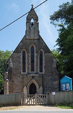
Ewshot
| Ewshot | |
| Hampshire | |
|---|---|
 St Mary's Church | |
| Location | |
| Grid reference: | SU816495 |
| Location: | 51°14’20"N, -0°49’59"W |
| Data | |
| Population: | 635 (2011) |
| Post town: | Farnham |
| Postcode: | GU10 |
| Local Government | |
| Council: | Hart |
| Parliamentary constituency: |
North East Hampshire |
Ewshot is a village in Hampshire, in the north east of the county, close to the Surrey border.
The name 'Ewshot' comes from Old English and means 'corner or angle of land where yew trees grow'.[1]
Ewshot consists of Ewshot Village proper, a later development known as Ewshot Heights plus the outlying hamlets of Beacon Hill, Warren, Dora's Green and a newer estate of large houses originally called Marlborough Hill at the top of Beacon Hill towards Farnham. Ewshot forms part of the Hundred of Crondall, which has origins dating back to the Domesday Book. It has a small Village Hall, a Residents Association.
The nearest towns are Fleet, Hampshire and Farnham, Surrey.
There is one Public House in Ewshot, called The Windmill.
The parish church, the Church of St Mary, was founded in 1873 and built in the Early English style.
Outside links
| ("Wikimedia Commons" has material about Ewshot) |
References
- ↑ Mills, Anthony David: 'A Dictionary of British Place-Names' (Oxford University Press, 2003) ISBN 978-0-19-852758-9
