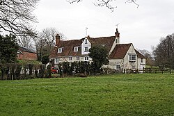
Durley Mill
| Durley Mill | |
| Hampshire | |
|---|---|
 Durley Mill | |
| Location | |
| Grid reference: | SU529152 |
| Location: | 50°56’2"N, 1°14’53"W |
| Data | |
| Postcode: | SO32 |
| Local Government | |
Durley Mill is a hamlet on the infant River Hamble, whose waters once drove the mill around which this hamlet grew, in Hampshire. It sits on a lone lane, halfway between Botley and Bishops Waltham. A mile to the north-west is Durley, itself just a small village.
The hamlet once had a railway station, Durley Halt, a small intermediate halt on the Bishops Waltham branch.[1]
See also
Outside links
- ↑ "The Bishops Waltham Branch" Simmonds,R/Robertson,K: Corhampton, Wild Swan, 1988 ISBN 0-906867-67-3

This Hampshire article is a stub: help to improve Wikishire by building it up.