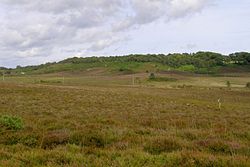
Castle Hill, Hampshire
| Castle Hill | |
|
Hampshire | |
|---|---|

| |
| Type: | Hill fort |
| Location | |
| Grid reference: | SU199039 |
| Location: | 50°50’5"N, 1°43’9"W |
| History | |
| Built Iron Age | |
| Information | |
Castle Hill is the site of an Iron Age univailate hillfort in the parish of Burley in the New Forest of tsouth-western Hampshire.
Its single rampart and ditch earthworks enclose approximately five acres of land and is in reasonable condition for the most part, although it is cut through by tracks leading to local houses. Parts of the interior are marshy and much of it is overgrown with oak, silver birch, holly and bracken.[1] The bank is at its highest on the eastern side, as the west side slopes steeply away.[2]
According to legend, the hill apparently was once the home to a local dragon, duly slain by a knight from the nearby village of Brook; and thus the local pub at Brook bears the name of the Green Dragon.[3]

Location
The site lies immediately to the west of the village of Burley Street, within the New Forest national park in the county of Hampshire. The site is on a small hill climbing to 302 feet above sea level.
The site is within the parish of Burley, whose name may be derived from the Anglo-Saxon bury which means a 'fortified place'[1]
References
- ↑ 1.0 1.1 Megalithic Portal: Castle Hill
- ↑ Castle Hill: The Modern Antiquarian
- ↑ Heathcote, Terry (1997). Discovering the New Forest. Halsgrove.