Blackmoor, Hampshire
| Blackmoor | |
| Hampshire | |
|---|---|
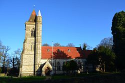
 St Matthew's, Blackmoor | |
| Location | |
| Grid reference: | SU779335 |
| Location: | 51°5’45"N, -0°53’16"W |
| Data | |
| Post town: | Liss |
| Postcode: | GU33 |
| Local Government | |
| Council: | East Hampshire |
| Parliamentary constituency: |
East Hampshire |
Blackmoor is a village in the east of Hampshire, about a mile and a half south-west of Bordon, just west of the A325 road, and on the west side of the Woolmer Forest. It is five miles due west of the border of Surrey, and as close to the border of Sussex.
The parish church is St Matthew's, designed by the Victorian Architect Alfred Waterhouse in the Victorian Gothic Style.[1]
Outside links
| ("Wikimedia Commons" has material about Blackmoor, Hampshire) |
