King's Hill, Hampshire
| King's Hill | |||
| Hampshire | |||
|---|---|---|---|
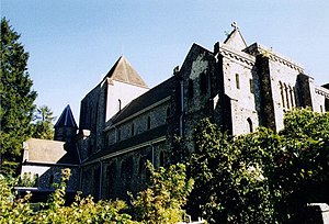
 Alton Abbey near the summit of King's Hill | |||
| Range: | Hampshire Downs | ||
| Summit: | 715 feet SU672375 51°8’1"N, 1°2’27"W | ||
King's Hill amongst the Hampshire Downs is one of the highest points in the east of Hampshire. It reaches 715 feet above sea level; dwarfed by some hills on the Berkshire border to the north such as Walbury Hill (974 feet), the county top, but overtopping all in its own area. Its prominence of 46 metres qualifies it as one of England's 'TuMPs' (Thirty and upwards Metre Prominence).
King's Hill is in the parish of Bentworth. Its top is on the Abbey Road between the villages of Medstead and Beech. Close by the highest point is Alton Abbey. Chawton Park Wood lies to the south of the open hilltop.