Barford, Hampshire
| Barford | |
| Hampshire | |
|---|---|
 Barford Mill | |
| Location | |
| Grid reference: | SU853373 |
| Location: | 51°7’44"N, -0°46’57"W |
| Data | |
| Post town: | Guildford |
| Postcode: | GU26 |
| Dialling code: | 01428 |
| Local Government | |
| Council: | East Hampshire |
| Parliamentary constituency: |
East Hampshire |
Barford is a scattered hamlet by Headley in Hampshire. It is in the very east of the county, nestled up against the border of Hampshire- with Surrey. The county border here is a stream, across which is Churt. Barford is some two miles north-west of Hindhead in the latter county. Its nearest Hampshire town is Bordon, which is some three and a half miles south-west from the village.
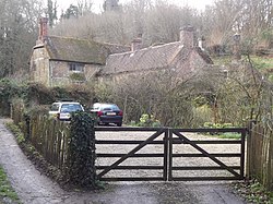
The stream which marks the parish and county boundary once had three mills, all now private dwellings. Two were involved in paper-making, and one corn-grinding. The oldest is mentioned in a pipe-roll of 1264 while the others date from the 18th century. One of the paper mills was subsequently used for flock,[1] and one housed French prisoners of war during the Napoleonic Wars.
Barford Bridge, formerly a dangerous ford, was built across the stream in the early 1900s.
References
- ↑ A History of the County of Hampshire - Volume 3 pp 51-55: Parishes: Headley (Victoria County History)