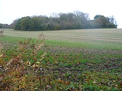
Barley Pound
| Barley Pound | |
|
Hampshire | |
|---|---|
 Barley Pound | |
| Type: | Ring and bailey |
| Location | |
| Grid reference: | SU79654665 |
| Location: | 51°12’49"N, -0°51’40"W |
| History | |
| Information | |
| Condition: | Earthworks remain |
Barley Pound is the site of a castle which one stood by Crondall in the east of Hampshire, close to the border of Surrey. It is a large ring-motte with four baileys and is one of the best examples of a ring and bailey fortress in Hampshire.
The fortification may be the "Lidelea Castle" which was mentioned in the Gesta Stephani for 1147, when it was besieged and captured by King Stephen. After its return to Henry of Blois, Bishop of Winchester it was abandoned in favour of Farnham Castle. Archaeological work has uncovered evidence of an 8-inch thick wall along with a masonry keep.[1]
To the east are the earthworks of Powderham Castle, which was a siege-castle to Barley Pound. It too was founded by the Bishop of Winchester and built during The Anarchy in the reign of King Stephen. It was originally an earth and timber ringwork fortress, encased by a ditch and with a counterscarp bank. Due to the demolition of its encasing rampart, the ringwork now resembles a low flat-topped motte. It now also has a dense cover of trees. Excavations on the mound have uncovered post-holes and large flints which may indicate former buildings.
References
- ↑ Barron, William (1985). The Castles of Hampshire & Isle of Wight. Paul Cave Publications. p. 6. ISBN 0-86146-048-0.