Downside, Surrey
| Downside | |
| Surrey | |
|---|---|
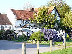
 The Cricketers' Inn, Downside | |
| Location | |
| Grid reference: | TQ109581 |
| Location: | 51°18’42"N, 0°24’34"W |
| Data | |
| Population: | 6,564 (2011) |
| Post town: | Cobham |
| Postcode: | KT11 |
| Dialling code: | 01932 |
| Local Government | |
| Council: | Elmbridge |
| Parliamentary constituency: |
Esher and |
Downside is a small village in Surrey, centred on Downside Common, south of Cobham and somewhat cut off beyond the River Mole, standing amidst the open countryside with Cobham and Stoke D'Abernon to the north and East Horsley further to the south. Two similar size villages sit across the expanse of Wisley Heath and Ockham Common: Ockham and Wisley to the west.
Most of the cottages and other buildings of the village form a cluster. It has an inn, Downside Sports and Social Club, regular village hall events and an annual sports day.
This village is part of the Metropolitan Green Belt, a settling slightly spoiled by the M25 motorway slicing throigh mercilessly immediately to the south of the village. To the north is Cobham Park, a large country house that has been converted to apartments.

Downside has a large village green, on the northern edge of which is the Cricketers' Inn, dating at its core to the 17th century and a Grade II listed building.[1] Immediately off the green in the south east corner is a listed hand-operated water pump.[2]
Parish church
St Michael's Chapel by the village green serves the village's Church of England community and those seeking its help in the Diocese of Guildford, at the end of the only fully developed street.[3]
History
The village was anciently a tything named after the Downe family, where they had lived since at least the 12th century.[4][5]
in 1331 the Prior and Convent of Newark by Guildford acquired a hundred acres from John Prudhomme held of Henry de Somerbury, who held of Henry atte Downe, who held of Chertsey Abbey.[5] Cobham Park was first known as 'Downe Place' after this family.[4] Much of the village green was part of a common open to those with villager status of the Downeside Tything as opposed to the two others: Street Cobham and Church Cobham. As to the manors that were in private hands in the Middle Ages.
The church became tied with that of Ockham at an unknown date after its 19th-century construction.
Downside Village was designated as a Conservation Area in 1979, focussed around its developed, village green area.
Culture and Community
Downside Sports & Social Club operate with a mixture of cricket, bowls, football and entertainment. Downside Village Hall hosts voluntary-run classes and meetings for local groups and organisations.
Downside village green, historically and legally 'Downside Common', is the setting for the Downside & Hatchford Sports Day, held annually on August Bank Holiday Monday.
Outside links
| ("Wikimedia Commons" has material about Downside, Surrey) |
References
- ↑ National Heritage List 1294555: Cricketers' Inn (Grade II listing)
- ↑ National Heritage List 1030210: Water pump (Grade II listing)
- ↑ St Michael's Chapel, Downside: A Church Near You
- ↑ Jump up to: 4.0 4.1 Edward Wedlake Brayley; John Britton (1841). A topographical history of Surrey, by E.W. Brayley assisted by J. Britton and E.W. Brayley, jun. The geological section by G. Mantell. pp. 412–. https://books.google.com/books?id=9bYHAAAAQAAJ&pg=PA412. Retrieved 14 April 2013.
- ↑ Jump up to: 5.0 5.1 A History of the County of Surrey - Volume 3 pp 442-447: Parishes: Cobham (Victoria County History)