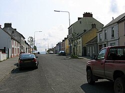
St Johnston
| St Johnston Irish: Baile Suingean | |
| County Donegal | |
|---|---|
 Main Street, St Johnston | |
| Location | |
| Grid reference: | 54.934722222, -7.458333333@ |
| Location: | 54°56’5"N, 7°27’30"W |
| Data | |
| Population: | 523 (2016) |
| Local Government | |
| Dáil constituency: |
Donegal |
| Website: | stjohnstonandcarrigans.com |
St Johnston is a village and townland in County Donegal, in the Laggan district in the east of the county, standing on the left bank of the River Foyle,[1] in the Barony of Raphoe North.[2]
The village is found along the R236 Lifford–Newtowncunningham road where it overlaps the R265 Carrigans to Raphoe) road, and about seven and a half miles south of Londonderry.

Churches
St Baithin's Church (popularly known as 'the Chapel'), the Roman Catholic parish church in the village, was designed by E. W. Godwin, the mid-Victorian architect. It is a neo-Gothic structure that was built between 1857 and 1860.[3]
St Johnston Presbyterian Church, on the Londonderry Road, is the other main structure within the village. Parts of this kirk may date from around 1724, but most of the present neo-Gothic structure was built in the early nineteenth century. The 'thin' neo-Gothic tower was built in 1849. [3] This church was severely damaged by a lightning strike in the mid-1980s. The tower of the church was particularly damaged. The building, however, which serves the large Ulster Scots Presbyterian community in this part of The Laggan, and had been fully restored by around 1990.
History
Mongavlin Castle (also known as Mongevlin Castle), a ruined castle about two miles south of the village was once a stronghold of the O'Donnell clan, Kings of Tír Chonaill. In the very early seventeenth-century, Mongevlin was the chief residence of Iníon Dubh (d. 1608), the daughter of both Séamus Mac Dhòmhnaill, 6th Laird of Dunnyveg, an Islay-based Gaelic nobleman, and his wife, Lady Agnes Campbell; Iníon Dubh was the mother of Red Hugh O'Donnell. When Iníon Dubh came to Ulster to marry Sir Aodh mac Maghnusa Ó Domhnaill (Sir Hugh O'Donnell, she brought a force of 100 of the biggest men she could find in Scotland for protection: eighty of these were of the name of Crawford. When Mongavlin was eventually abandoned, the Crawfords settled and married in the locality. Many of their descendants can still be found in the area to this day.
On 23 July 1610, at the start of the Plantation of Ulster, Mongevlin Castle and its lands were granted to Ludovic Stewart, 2nd Duke of Lennox (1574-1624). Lennox, who was already a peer in the Peerage of Scotland, was created the 1st Duke of Richmond in the Peerage of England in 1623, making him a duke twice over. On his death on 16 February 1624 the title of Duke of Lennox and the castle and lands at Mongavlin passed to his brother Esmé, 1st Earl of March (1579-1624), who now became (briefly) the 3rd Duke of Lennox. Esmé had married Katherine Clifton (c. 1592–1637) in 1609; she became the 2nd Baroness Clifton, suo jure, in 1618. After her husband Esmé's death in August 1624, Katherine, now Dowager Duchess of Lennox, then married James Hamilton, 2nd Earl of Abercorn (c. 1604 - c. 1670) around 1632. Unlike the Dukes of Lennox, Lord Abercorn had actually moved to Ulster, where he was now based. The centre of Lord Abercorn's estate was the nearby town of Strabane in western Tyrone.
A borough was established at the site in the reign of King James VI & I during the Plantation of Ulster. St Johnstown Borough was a borough constituency in the Irish House of Commons from about 1619 to the Acts of Union 1800. The borough was a rotten borough and the settlement never more than a village.[1]
King James II & VII passed through on his way to the Siege of Derry in 1690. From St Johnston he sent a letter proposing surrender, which was rejected.
The town had a station on the Great Northern Railway (the GNR) which was closed in 1965.[4] (The nearest railway station is now in Londonderry.)
St Johnston was one of several Protestant villages in eastern Donegal that would have been transferred to Northern Ireland, had the recommendations of the Irish Boundary Commission been enacted in 1925.[5]
Sports
- Cricket: St Johnston Cricket Club, founded in 1898[6]
- Football: Kildrum Tigers Football Club, sometimes known as 'the Wee Toun'
- Bowling
Outside links
References
- ↑ 1.0 1.1 Lewis, Samuel: 'A Topographical Dictionary of Ireland' (S. Lewis and Co., 1842)
- ↑ Baile Suingean / Saint Johnstown: Placenames Database of Ireland
- ↑ 3.0 3.1 Nikolaus Pevsner: Pevsner Architectural Guides
- ↑ "Irish railways". Railscot - Irish Railways. http://www.railscot.co.uk/Ireland/Irish_railways.pdf.
- ↑ "Irish Boundary Commission Report". National Archives. 1925. pp. 140–43. http://discovery.nationalarchives.gov.uk/details/r/C386829.
- ↑ St Johnston Cricket Club : history. Stjohnstoncc.hitscricket.com. Retrieved on 23 July 2013.