Nesting
| Nesting | |
| Shetland | |
|---|---|
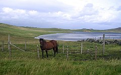
 Loch of Benston | |
| Island: | Mainland, Shetland; Whalsay; Out Skerries |
Nesting is a parish of Shetland. It spreads over part of the east of Mainland, Shetland and encompasses also the islands of Whalsay and the Out Skerries. On Mainland the parish takes in about twelve miles by four, on coast and seaboard from Gletness to Lunna Ness.
The parish is much diversified on all its coasts by voes and headlands. The land comprises only about 1,000 acres in tillage, and is mostly pastoral, or waste.
Nesting is generally divided into a north and south district.
Settlements in Nesting include:
- Benston (South Nesting)
- Billister (North Nesting)
- Brettabister
- Catfirth (South Nesting)
- Dury (North Nesting)
- Freester (South Nesting)
- Gletness (South Nesting), including North and South Isles of Gletness
- Kirkabister (North Nesting)
- Laxfirth (North Nesting)
- Skellister (South Nesting)

Outside links
References
- Wilson, Rev. John: The Gazetteer of Scotland (Edinburgh, 1882)