Aghabullogue
| Aghabulloge Irish: Achadh Bolg | |
| County Cork | |
|---|---|
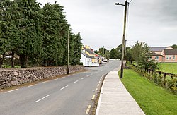
 Main road through Aghabullogue | |
| Location | |
| Grid reference: | W445772 |
| Location: | 51°56’40"N, 8°48’28"W |
| Data | |
| Local Government | |
Aghabullogue or Aghabulloge is a village in the barony of Muskerry East in north-westerm County Cork. It stands around 19 miles west of Cork City, south of the Boggeragh Mountains and north of the River Lee.
The parish of Aghabullogue includes the villages of Aghabullogue, Coachford and Rylane.
It has a public house and shop, a national school, community hall and a Roman Catholic church. Saint Olan (or Olann) is the patron saint of the parish.
Sport
- Aghabullogue GAA
References
This County Cork article is a stub: help to improve Wikishire by building it up.