Spion Kop, Nottinghamshire
| Spion Kop | |
| Nottinghamshire | |
|---|---|
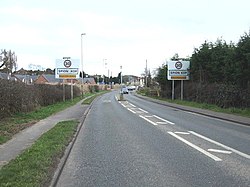
 The A60 approaching Spion Kop | |
| Location | |
| Grid reference: | SK555665 |
| Location: | 53°11’32"N, 1°9’52"W |
| Data | |
| Post town: | Mansfield |
| Postcode: | NG20 |
| Local Government | |
| Council: | Mansfield |
| Parliamentary constituency: |
Mansfield |
Spion Kop is a small residential and former industrial area in Nottinghamshire, stretching for a few hundred yards on both sides of the main A60 road surrounded by open farmland.
It is located about a mile to the south of Warsop on the A60, Mansfield Road. It is a settlement built and named after the Battle of Spion Kop which took place during the Second Boer War in Natal, South Africa, in January 1900.[1] A major military figure in the conflict was John Talbot Coke, grandson of D'Ewes Coke, born at Mansfield Woodhouse, a well-known Nottinghamshire industrialist and clergyman. At Mansfield Woodhouse a Coke Street was renamed Newhaven Avenue.
The one residential side-street adjoining the main A60 road formerly known as George Street has been renamed Mosscar Close.
A modern, large-scale mixed-residential development has been built on the extensive site of the old Wood Brothers timber business on Mansfield Road since 2011.
Outside links
| ("Wikimedia Commons" has material about Spion Kop, Nottinghamshire) |
References
- ↑ Warsop Web Retrieved 27 August 2014

This Nottinghamshire article is a stub: help to improve Wikishire by building it up.
