Ompton
| Ompton | |
| Nottinghamshire | |
|---|---|

| |
| Location | |
| Grid reference: | SK688651 |
| Location: | 53°10’48"N, -0°58’12"W |
| Data | |
| Population: | 449 (2011 (with Laxton, Moorhouse and Ossington) |
| Post town: | Retforrd |
| Postcode: | NG22 |
| Local Government | |
| Council: | Newark and Sherwood |
| Parliamentary constituency: |
Newark |
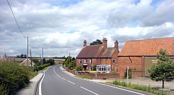
Ompton is a village in Nottinghamshire, three miles south-east of Ollerton. To the south-west stands Kneesall and to the north-west Wellow.
The village has a red-brick chapel of 1860, while about half a mile to the west is a water pumping station, built 1965–68 as a tiled pyramid on a glazed plinth.[1]
Outside links
| ("Wikimedia Commons" has material about Ompton) |
References
- ↑ Nikolaus Pevsner: The Buildings of England: Nottinghamshire, 1951; 1979 Penguin Books ISBN 978-0-300-09636-1page 282

This Nottinghamshire article is a stub: help to improve Wikishire by building it up.
