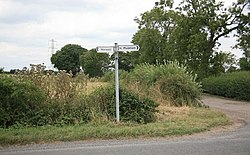
Bathley
| Bathley | |
| Nottinghamshire | |
|---|---|
 Foxholes Farm, Bathley | |
| Location | |
| Grid reference: | SK776591 |
| Location: | 53°7’24"N, -0°50’21"W |
| Data | |
| Population: | 246 (2011) |
| Post town: | Nottingham |
| Postcode: | NG23 |
| Local Government | |
| Council: | Newark and Sherwood |
| Parliamentary constituency: |
Newark |
Bathley is a village in Nottinghamshire, to the north-west of Newark-on-Trent. It is at a meeting of minor lanes a mile west of North Muskham. The 2001 census and the 2011 census both recorded a population of 246.
Bathley is recorded in the Domesday Book as Badeleie.[1]
As Bathley does not have a hall of any sort, the Crown Inn public house is used for family parties, christenings and funerals as well as Parish Council meetings.
Outside links
| ("Wikimedia Commons" has material about Bathley) |
References
- ↑ Bathley in the Domesday Book

This Nottinghamshire article is a stub: help to improve Wikishire by building it up.
