Tur Langton
| Tur Langton | |
| Leicestershire | |
|---|---|
 Tur Langton | |
| Location | |
| Grid reference: | SP714946 |
| Location: | 52°32’42"N, -0°56’56"W |
| Data | |
| Population: | 316 (2011) |
| Post town: | Tur Langton |
| Postcode: | LE8 |
| Dialling code: | 01858 |
| Local Government | |
| Council: | Harborough |
Tur Langton is a small village in Leicestershire.
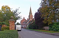
The village has a parish church, St Andrew's, and one pub, The Crown Inn, both situated in the centre of the village. The next nearest settlement of significant size is the civil parish Kibworth Harcourt, found approximately one mile west of Tur Langton. The 2011 census recorded a population (including Shangton) of 316.
History
One of the earliest recorded mentions of the existence of Tur Langton is found in the Domesday Book of 1086, in which it is listed as 'Terlintone'.[1] Tur Langton's present day name does not appear to have been established until at least the late 16th century, despite its inclusion in the small hundred of Langton in the 1130 Leicestershire Survey and the parish itself being recognised as part of the ecclesiastical parish of Church Langton since 1220.
In July 1645, King Charles briefly visited Tur Langton to rest and water his horse in his departure from the Battle of Naseby. The battle, which took place in June of the same year in the village of Naseby, Northamptonshire, was the decisive battle of the Civil War at which parliament's New Model Army defeated King Charles' main field army.[2] The well, a chalybeate spring in the eastern half of the parish, at which King Charles watered his horse still stands in Tur Langton today, now named 'King Charles Well'.[3]
Up until the 17th century, the reigning Archbishop of York was regarded as the overlord of the manor, which was attached to the manor of Southwell in Nottinghamshire. One of the longest family ownerships of the manor was by the Maunsell family. Prior to 1166, the Archbishop of York at the time had granted residency of the manor to Robert Maunsell, a residency which remained in the hands of his male descendants until 1352. Robert Maunsell did lose the manor for four years during this period (1216-1220) as a result of rebellion; the manor was forfeited to the crown and King John granted the manor to Hugh de Luterington. Following the Maunsell's residency, the manor changed hands several times in the succeeding centuries, switching families through marriage and changes of the Archbishop of York.[4]
The 1870s, the Imperial Gazetteer of England and Wales described Tur Langton as:
- '...a township, with a village, in Church-Langton parish, Leicester; 2 miles E by N of Kibworth r. station, and 5¼ N of Market-Harborough. Real property, £3,278. Pop., 337. Houses, 90. A church is here, as a chapel to Church-Langton; is a small old building with a turret; and was about to be restored in 1864, at a cost of about £1,000. There is also an Independent chapel. Charles I., in his flight from the battle of Naseby, watered his horse here, at a place still called King Charles' Well.'[5]
Churches

Before the construction of St Andrews Church in 1866, Tur Langton's sole place of worship was a small chapel, which was reported to be a 'wretched structure' as early as 1832. The majority of the old chapel was disassembled whilst the new church was being built.
St Andrews church, designed by Joseph Goddard, was funded by Hanbury's Charity; this was a fund of approximately £2,000 left by the Reverend William Hanbury upon his death for the purpose of the construction of features, such as churches, in the local area.[6] Built on Main Street and still standing today, the church was fashioned in a Victorian Style and dedicated to St Andrew.[3]
About the village
The former Manor House, now part of a farm, stands at the end of a short avenue at the west end of the village. Made of stone, it was constructed on an H-shaped plan dating from the 17th century, standing two stories tall. All that remains today is the central block, which originally contained a great hall. Although there is no record of its structural history before its 17th century plans, there are records of the manor's ownership.
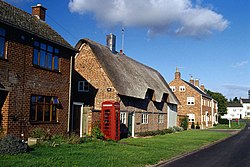
The majority of the residencies on Main Street are built of red brick or ironstone, with most houses containing ceiling beams inscribed with the house's date of construction. Despite significant rebuilding of Tur Langton from 1700 onwards, many houses contain ceiling beams which display a 17th-century origin. There is some social housing in Tur Langton, built in the 1930s and 1940s. Towards the west end of Main Street is Tur Langton's village hall. A wooden army hut bought from Cannock Chase, Staffordshire, it was constructed by public subscription after First World War.[7]
Outside links
| ("Wikimedia Commons" has material about Tur Langton) |
References
- ↑ Mills, Anthony David: 'A Dictionary of British Place-Names' (Oxford University Press, 2003) ISBN 978-0-19-852758-9
- ↑ "Battle of Naseby". Battlefields Trust. http://www.battlefieldstrust.com/resource-centre/mediæval/battleview.asp?BattleFieldId=51.
- ↑ 3.0 3.1 Information on Tur Langton from GENUKI
- ↑ Lee, J.M.. "'Church Langton', A History of the County of Leicestershire: Volume 5: Gartree Hundred". http://www.british-history.ac.uk/report.aspx?compid=22059.
- ↑ Wilson, John Marius (1870–72). Gazetteer of England and Wales (1st ed.). Edinburgh: A.Fullarton & Co.. http://www.visionofbritain.org.uk/place/10983. Retrieved 5 February 2014.
- ↑ Calder, Jonathan. "Hanbury's Charity: Church Langton to Westminster". Liberal England. http://liberalengland.blogspot.co.uk/2009/10/hanburys-charity-church-langton-to.html.
- ↑ A History of the County of Leicester - Volume 5 pp 193-213: Church Langton (Victoria County History)
