Hulcote, Bedfordshire
| Hulcote | |
| Bedfordshire | |
|---|---|
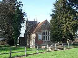
 Hulcote church | |
| Location | |
| Grid reference: | SP950382 |
| Location: | 52°2’4"N, -0°36’55"W |
| Data | |
| Post town: | Milton Keynes |
| Postcode: | MK17 |
| Dialling code: | 01908 |
| Local Government | |
| Council: | Central Bedfordshire |
| Parliamentary constituency: |
Mid Bedfordshire |
Hulcote or Holcot is a small village and ancient parish in the Manshead Hundred of Bedfordshire.
Some evidence has been found indicating possible Neolithic, New Stone Age and Roman settlement in the area. However, it is known that Hulcote has been consistently occupied since the Dark Ages.[1]
The church of St Nicholas is Grade-I listed. It became a listed building on 23 January 1961.[2]
The ecclesiastical parishes of Hulcote and Salford were united in 1750. The civil parish of Hulcote and Salford was formed in 1933.[1]
Today, Hulcote is located directly to the north of the M1 motorway, close to Milton Keynes in Buckinghamshire.
References
- ↑ 1.0 1.1 "Hosted By Bedford Borough Council: Hulcote introduction". Bedfordshire.gov.uk. 2008-01-30. https://web.archive.org/web/20120306061736/http://www.bedfordshire.gov.uk/CommunityAndLiving/ArchivesAndRecordOffice/CommunityArchives/Hulcote/HulcoteIntroduction.aspx.
- ↑ "Church of St Nicholas - 1114036". Historic England. https://historicengland.org.uk/listing/the-list/list-entry/1114036. Retrieved 13 October 2019.
Outside links
| ("Wikimedia Commons" has material about Hulcote, Bedfordshire) |

This Bedfordshire article is a stub: help to improve Wikishire by building it up.
