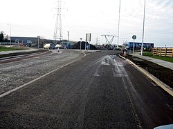
Damastown
| Damastown | |
| County Dublin | |
|---|---|
 Damastown Avenue | |
| Location | |
| Grid reference: | O127569 |
| Location: | 53°33’-0"N, 6°18’-0"W |
| Data | |
| Postcode: | D15 |
| Local Government | |
Damastown is a townland in the parish of Mulhuddart in County Dublin, and in thr Barony of Castleknock.[1] It is located west of the village of Mulhuddart and is north of the N3 road. A 1.1 mile (1.8 km) link road is nearing completion to link Damastown to the Cruiserath Road intersecting Church Road which links Mulhuddart to Tyrrelstown.
A temporary recycling centre was set up in Damastown to allow for an upgrade to the Coolmine recycling centre. Companies with premises in the industrial estate include IBM and Gem Pack Foods.[2]