Carrickmines
| Carrickmines Irish: Carraig Mhaighin | |
| County Dublin | |
|---|---|
 Carrickmines Retail Park | |
| Location | |
| Grid reference: | O236249 |
| Location: | 53°14’53"N, 6°10’52"W |
| Data | |
| Population: | 6,088 (2006) |
| Postcode: | D18 |
| Dialling code: | 01 |
| Local Government | |
| Council: | Dún Laoghaire–Rathdown |
Carrickmines is a village of County Dublin which is effectively now an outer suburb of the City of Dublin. The area, still semi-rural, was historically on the border of the Pale and featured a defensive construction, Carrickmines Castle, which became the subject of national controversy during the building of a late stage of Dublin's M50 orbital motorway.
The name of the village is from the Irish Carraig Mhaighin meaning 'Plateau of rock'.
Character
Traditionally a rural area, and today a semi-rural suburban region, Carrickmines is now divided north-east/south-west by the M50 motorway, with, to the north-east, more established residential areas, and to the southwest, including along Glenamuck Road, new retail parks, office buildings, housing schemes and apartments.
Carrickmines developed as a settlement in the more than four miles long valley of the same name, which contains the modest Carrickmines River and its tributaries. The Ballyogan, Glenamuck and Golf Streams all merge in the vicinity. Downstream at Brennanstown the river merges with St. Bride's Stream, from Foxrock, to form the Loughlinstown River, which in turn meets the Bride's Glen Stream to form the Shanganagh River, which reaches the sea at Killiney Strand.
Leopardstown stands to the northwest, Foxrock to the north, Cabinteely to the north-east and Brennanstown to the east, Ballyogan to the west, Glenamuck to the south, and Laughanstown and Lehaunstown to the south-east.
Development

During the construction of the M50 motorway, Carrickmines gained national notoriety when anti-roads protesters calling themselves the Carrickminders set up camp in the area and delayed the completion of the M50 for two years with legal challenges being taken by Vincent Salafia. The objectors claimed that the underground remains of Carrickmines Castle, built in the 12th century on the edge of the Pale, was of national importance. Today, much of the uncovered remains are preserved in tunnels and other structures scattered around the interchange. The council claimed the action greatly increased the cost of the project, which was eventually completed in August 2005.
Junction 15 of the M50 lies at the centre of Carrickmines. The retail park and developments on Glenamuck Road have converted the semi-rural area into a mix of suburban complex, with shops, offices, apartment blocks and housing estates, and a patchwork of remaining farmland.Template:Fact
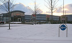
The retail park at Carrickmines, The Park Carrickmines, contains a mixture of retail and office space. It was sold for €100m in 2006,[1] and reportedly garnered the highest retail park rents in Ireland in 2014.[2] In 2015 it was reported as the best performing Irish retail park by The Sunday Times.[3]
On 10 October 2015, a large fire swept through a halting site on Glenamuck Road.[4]
In literature
Carrickmines is mentioned in James Joyce's novel A Portrait of the Artist as a Young Man, in which it is described as an area dominated by fields.
| ("Wikimedia Commons" has material about Carrickmines) |
References
- ↑ O'Dwyer, Peter (2014-07-31). "Nama to sell retail parks portfolio". Irish Examiner. http://www.irishexaminer.com/business/nama-to-sell-retail-parks-portfolio-277268.html.
- ↑ McNieve, Paul (2014-09-18). "So where to now for Ireland's retail park players?". Irish Independent (Independent News & Media). http://www.independent.ie/business/commercial-property/so-where-to-now-for-irelands-retail-park-players-30594344.html.
- ↑ McCaughren, Samantha (2015-04-19). "Retailers struggle in ‘unhealthy’ shopping parks". The Sunday Times. http://www.thesundaytimes.co.uk/sto/news/ireland/Business/article1545629.ece?CMP=OTH-gnws-standard-2015_04_18.
- ↑ Edwards, Elaine (12 October 2015). "Carrickmines fire: Two children remain in hospital". The Irish Times. http://www.irishtimes.com/news/ireland/irish-news/carrickmines-fire-two-children-remain-in-hospital-1.2388919.