Drumskinny
| Drumskinny | |
| Fermanagh | |
|---|---|
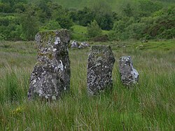
 Standing stones by Drumskinny | |
| Location | |
| Grid reference: | H201707 |
| Location: | 54°35’4"N, 7°41’24"W |
| Data | |
| Postcode: | BT |
| Dialling code: | 028 |
| Local Government | |
| Council: | Fermanagh and Omagh |
| Parliamentary constituency: |
Fermanagh and South Tyrone |
Drumskinny is a townland in Fermanagh, best known for an ancient stone circle.
The name of the place is from Droim Scine, meaning 'Ridge of the knife (or edge)'[1]
The townland is the site of a stone circle (H2007072). With the inclusion of an adjacent cairn and alignment, the stone circle is a State Care Historic Monument.[2][3] The site was excavated in 1962[4] and is believed to have built around 2000 BC.[5]
(There are also two other townlands in Ulster called 'Drumskinny', both in Tyrone.)
Outside links
| ("Wikimedia Commons" has material about Drumskinny) |
References
- ↑ Drumskinny - Placenames NI
- ↑ List of State Care Monuments (Historic Environment Division)
- ↑ Megalithic Portal: Drumskinny
- ↑ "Drumskinny Stone Circle". Irish Antiquities. http://irishantiquities.bravehost.com/fermanagh/drumskinny/drumskinny.html. Retrieved 2010-10-06.
- ↑ "Drumskinny Stone Circle". Triskelle. http://www.triskelle.eu/attractions/drumskinnystonecircle.php?index=100.040.008.060.005. Retrieved 2007-12-02.
