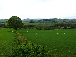
Haugh Head, Northumberland
From Wikishire
Revision as of 21:13, 8 December 2020 by RB (Talk | contribs) (Created page with "{{Infobox town |name=Haugh Head |county=Northumberland |picture=Haugh Head - geograph.org.uk - 411846.jpg |picture caption=Fields by Haugh Head |os grid ref=NU002260 |latitude...")
| Haugh Head | |
| Northumberland | |
|---|---|
 Fields by Haugh Head | |
| Location | |
| Grid reference: | NU002260 |
| Location: | 55°31’42"N, 1°59’52"W |
| Data | |
| Postcode: | NE71 |
| Local Government | |
Haugh Head is a hamlet in Northumberland, along the A697 south of Wooler. It is found on the east side of the Wooler Water, which may be forded here. The old railway line up the valley has been closed and lifted, but an old signal box still stands in Haugh Head.
To the north-east is a pele tower in a smaller hamlet known as Tower Martin.