Winthorpe, Nottinghamshire
| Winthorpe | |
| Nottinghamshire | |
|---|---|
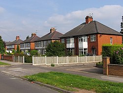
 Houses on Winthorpe Road, Winthorpe | |
| Location | |
| Grid reference: | SK801537 |
| Location: | 53°6’15"N, -0°47’10"W |
| Data | |
| Population: | 650 (2011) |
| Post town: | Newark |
| Postcode: | NG24 |
| Dialling code: | 01636 |
| Local Government | |
| Council: | Newark and Sherwood |
| Parliamentary constituency: |
Newark |
Winthorpe is a village in Nottinghamshire found two miles north-east of Newark-on-Trent. The population at the 2011 census was 650.
The parish church is All Saints' Church.

About the village
Newark Air Museum is an air museum located on the former Royal Air Force station, RAF Winthorpe.[1] The airfield was mainly used for training Lancaster crews.[2]
Society and sport
Winthorpe has a village hall, a local pub called the Lord Nelson and a community centre where the events range from a monthly lunch club to an annual Bonfire Night celebration.
Winthorpe also has a long-standing cricket tradition and has been the home to Winthorpe Cricket Club since 1887.[3]
Outside links
| ("Wikimedia Commons" has material about Winthorpe, Nottinghamshire) |
References
- ↑ "Newark Air Museum". newarkairmuseum.org. 2011. http://www.newarkairmuseum.org/. Retrieved 29 August 2011.
- ↑ "The History of Winthorpe Airfield | Winthorpe Village, Nottinghamshire". winthorpe.org.uk. 2011. http://www.winthorpe.org.uk/the-history-of-winthorpe-airfield. Retrieved 29 August 2011.
- ↑ Winthorpe Cricket Club history
