Shelsley Walsh
| Shelsley Walsh | |
| Worcestershire | |
|---|---|
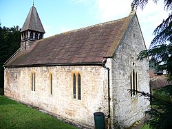
 St Andrew's church Shelsley Walsh | |
| Location | |
| Location: | 52°15’51"N, 2°24’36"W |
| Data | |
| Post town: | Worcester |
| Postcode: | WR6 |
| Local Government | |
| Council: | Malvern Hills |
| Parliamentary constituency: |
West Worcestershire |
Shelsley Walsh is a small village and parish in the Doddingtree hundred Worcestershire, at the top of the western valley side of the River Teme. Its population at the time of the 2001 Census was just 31.
Shelsley Walsh forms part of the upper division of Doddingtree.[1] St Andrew's church is of 13th century origin.[2]
Shelsley Walsh is widely known among motorsport enthusiasts because of its association with the Shelsley Walsh Speed Hill Climb, which has been run since 1905.
Etymology
Shelsley Walsh means "clearing on a slope" from Old English scelf "shelf (of land)" and leāh "wood, clearing". The name was recorded as Scillislege in 948. The addition of Walsh to the name is from the surname Walsh, which means "of the Welsh", from Old English walas "foreigners". A record of the name as Shilsleywalish, undated, proves this.
References
- ↑ Morgan 2011, p. 20.
- ↑ Pevsner, Nikolaus and Brooks, Alan Worcestershire 2007 Yale University Press, London p594 ISBN 9780300112986
Outside links
| ("Wikimedia Commons" has material about Shelsley Walsh) |

This Worcestershire article is a stub: help to improve Wikishire by building it up.
