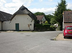
Woolsbridge
| Woolsbridge | |
| Dorset | |
|---|---|
 Woolsbridge, Old Barn Farm | |
| Location | |
| Grid reference: | SU097050 |
| Location: | 50°50’40"N, 1°51’46"W |
| Data | |
| Local Government | |
| Council: | Dorset |
Woolsbridge is a village in easternmost Dorset at the border with Hampshire, marked here by the Moors River which flows along the east side of the village and its developments. Woolsbridge is just the east of Three Legged Cross.
Woolsbridge was formerly under the control of the Earl of Normanton and is a part of the civil parish of Cranbourne.[1]
History
Woolsbridge was previously the terminus point of the A31 road which was widened in 1762 by an Act of the Parliament of Great Britain.[2] Since the A31 was extended in later years, the terminus is now a roundabout.[3]
The village is within a green belt.[4] It has an industrial estate near it which serves both Woolsbridge and Three Legged Cross.[5] In 2017, it had a new road built through it to facilitate access. In 2019, there was a further application to the council to build nineteen new units based on spare farmland that had previously been purchased for the construction of the road.[5] The council removed thirteen hectares of land from the green belt registration to permit this.[4] There is a campsite within it located on a working farm.[6]
Sport
- Football: Magpies and Woolsbridge United F.C..[7]
References
- ↑ The London Gazette
- ↑ Parliament (1803). Journals of the House of Commons. 29. H.M. Stationary Office. p. 273.
- ↑ Post reply (2019-11-16). "Part of the A31 will shut overnight until the end of November". Bournemouth Echo. https://www.bournemouthecho.co.uk/news/18040957.part-a31-will-shut-overnight-end-november/. Retrieved 2020-03-18.
- ↑ 4.0 4.1 Terms and Conditions. "Christchurch and East Dorset - East Dorset Local Plan Review Options Consultation - 5.4.16 Three Legged Cross". East Dorset District Council. http://christchurcheastdorset.dorsetforyou.com/portal/lp-review/lpreview-cbc-optionseddc?pointId=s152412294330392. Retrieved 2020-03-18.
- ↑ 5.0 5.1 "Woolsbridge industrial estate could be expanding". Bournemouth Echo. 2019-04-08. https://www.bournemouthecho.co.uk/news/17558168.woolsbridge-industrial-estate-could-be-expanding/. Retrieved 2020-03-18.
- ↑ "100 Top Campsites: Country Retreats - Campsites - Camping". Out and About Live. https://www.outandaboutlive.co.uk/camping/articles/campsites/100-top-campsites-country-retreats. Retrieved 2020-03-18.
- ↑ "Westover hit for six by cup specialists". Bournemouth Echo. 2008-04-07. https://www.bournemouthecho.co.uk/sport/2177025.westover-hit-for-six-by-cup-specialists/. Retrieved 2020-03-18.